Challenge(s)
How can the right balance be struck between the spatial needs of the port and city?
Good practice
Design a spatial layout that allows or preserves visual openings toward the water and the port
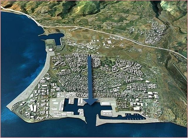
Occupied and empty spaces, visual perspectives, building heights, and volumetric shapes are all factors that can be altered to optimise the way port-city interface sites are integrated into the existing urban and port context. With careful planning, preserving and creating visual perspectives of the water, dock basins, and reclaimed port patrimony is possible. In Le Port, a master plan is redesigning the original port-oriented city to better connect the residents and port activities.
This good practice also includes objective 6.2 (Integrating spaces and functions open to residents and visitors alike into port facilities, enhancing the visibility of the port and its activities) of the AIVP's 2030 Agenda.
Case study
When it was founded in 1895, Le Port was originally a sole-purpose city, a tool organised specifically to further the economic development of the port and designed exclusively for the shipping of goods. During the 1960s, a dividing line gradually separated the city from the port and the sea. The railway closed down, and buildings were erected around the dock basins, forming a physical and symbolic boundary with the city.
The election of a new city government in 1971 marked a change. The first master plan ushered in a new approach to planning, centred on a commitment to creating a green, ocean-facing city. By then, five priorities were identified: 1) changing the climate through revegetation, 2) giving residents access to the sea, 3) planning the city as a whole unit, 4) defining a simple and effective traffic pattern, and 5) developing activity zones in harmony with the urban environment.
In March 2000, a new initiative was based on a land acquisition programme that extended to over 75% of the territory. It inspired a project named “Ville et Port, la ville est port” (City and Port, the city is the port), which led institutional partners to adopt a charter for its implementation. The project aimed to restore the historic port of Pointe des Galets, reestablishing its significance as a heritage of the island. By doing so, the city could reconnect with its original purpose of a symbiotic relationship between maritime and urban activities. The challenge was to transform the functional city, initially designed for shipping, and adopt a permeable design with a new traffic layout and open spaces, opening the waterfront area, which would become a new point of interest in its own right.
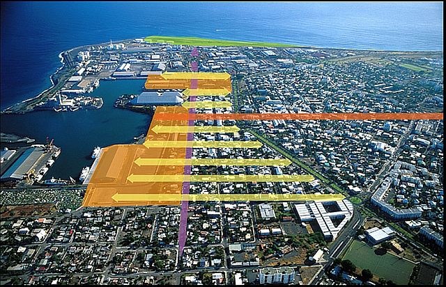
Another, more modern, challenge was consolidating the city to cope with population growth in a limited space while achieving energy self-sufficiency by 2030. One of the major developments in response to these issues is the creation of a central boulevard, the “Mail de l’Océan”, on which work was carried out from 2005 to 2014. This project made it possible to create a link between the historic centre and the more recent districts. It runs through the city for 2 km from east to west. The new road culminates at the Pointe des Galets, with a public space designed around the three “Grandes maisons”, large colonial-style houses. To integrate the new district into the port’s urban landscape, the buildings and public spaces were planned carefully, balancing occupied and unoccupied spaces. The design encourages leisurely strolls and provides shaded spots for relaxation.
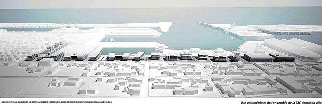
In 2017, the city revised its Local Urban Plan for 2030, including a Sustainable Planning and Development Project (PADD). The plan targets 40,000 inhabitants in 10 years, which implies continuing growth in residences and public spaces. The port city is planning 47 m2 of green spaces per inhabitant and is carrying out a new project called “Portes de l’océan” (Doors of the Ocean) to create new living spaces and economic activities near the port area. The operation started in 2020, and it is currently under development.
Additional information
https://www.ville-port.re/histoire/
https://www.ecoquartiers.logement.gouv.fr/operation/1779/
https://www.ville-port.re/le-projet-damenagement-et-de-developpement-durable-padd/
In images