Challenge(s)
How to encourage informal learning and inspire passersby to explore the riverbanks?
Good practice
Create informative panel to help present the port and the river
Interactive supports play a vital role in informal learning, as clear and engaging signage makes the history and significance of riverbanks accessible to all. These signs foster collaboration between experts and local communities, enhancing the integration of port activities into their surroundings. They also empower stakeholders to connect with and further explore the area. By incorporating waterway perspectives early in spatial planning and utilizing visual and narrative tools, cross-sector collaboration can be promoted and sustainable, long-term alignment ensured.
Case study
Ports de Lille aims to develop river freight and constantly strives to improve the coexistence of different activities on the same waterway.
The Connected River project is a EU-funded project, which aims to boost the capacity of multi-stakeholder ecosystems to deliver services that guarantee safety, accessibility, and livability of waterways & waterfronts in the North Sea Region. One of the experiments was led by Ports de Lille and aimed to connect stakeholders for innovative and sustainable solutions while ensuring safety, port activities’ acceptability and boost greater Lille’s attractiveness.
The riverbank signs project originated from an analysis indicating a concentration of activities and people along the Lille riverbanks. In addition, this same audience had limited environmental awareness and lacked opportunities for informal learning. The area lacked support encouraging discovery.
To solve these problems, a mobilisation of stakeholders was organised. Four types of stakeholders were identified: economic actors (boat renters, boatmen, ports…), institutional actors (City, region, police…), non-lucrative actors (walkers, fishermen, NGOs…) and managing authorities (such as Navigable Waterways of France). Small mixed workshops were organised so that users could meet and share their needs and their use of the riverbanks. From there, a cross-functional vision board was created. This board addressed the co-governance of the area, describing the expectations and issues of users. One of the proposals of this board was the creation of informative signs.
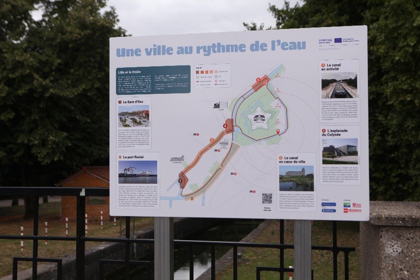
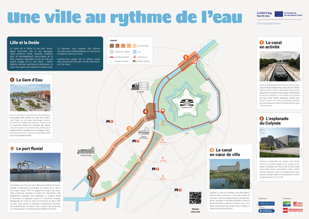
These panels, created in collaboration with local stakeholders, are designed to be both user-friendly and educational. Pedestrians are invited to learn more about the port’s and river’s heritage and how the waterway shaped the territory. The informative signs invite people to explore and inform themselves about what to expect within a 5 to20-minute walking distance. They are structured around a central map which presents the area, the localisation of the reader and recommended walking paths. Around the map, points of interest are described in greater detail with information such as their history or use.
These signs have had multiple benefits. The public is better informed and is now going further along the riverbanks. In addition, this experiment has improved cross-sector collaboration and long-term alignment. It helped to identify the needs and expectations of stakeholders better. People were invited to give their opinion on the project via online forms (QR codes) and street interviews.
Initial feedback suggests that the signs need to be better positioned (in the most frequented areas). Additional information on local flora and fauna to allow for better identification and protection of species is planned for the second round of experimentation. Various actors have expressed interest in multiplying the number of supports (stickers, flyers, etc.) and in reproducing the experiment in other locations. Other avenues for improvement include the choice of lesser-known locations and more synergy with tourism actors.
Additional information:
In images